ABOUT US
Aso Cycle Tourism School (Kogidasu)
At the Aso Cycle Tourism School, also known as Kogidasu, our mission is to share the attractions of Aso and its abundant nature through cycling tours. We welcome both visitors and members of the local community, who we hope to bring together through memorable and informative cycling tours.
At Kogidasu, we believe cycling is the ultimate way to enjoy sightseeing. Fast enough for visiting places too far to reach on foot, but slow enough to let riders take in the view, cycling is perfect for accessing famous sightseeing spots and discovering hidden gems that are easy to miss when traveling by car. For us, the journey is just as important as the destination.
Recommended route
Uchinomaki route
Cycle through a hot spring town
Uchinomaki is famed for its hot springs that flow into public baths and foot baths all over the town. This route goes through the town of Uchinomaki Onsen and the foothills of Kitagairinzan(the north-side outer rim of the Aso caldera), named the “Nabezuru” Line(“pot handle” in Japanese) due to its shape. Relax and enjoy the view of the town nestled between the crater rim and five peaks of Aso. This is an easy route with few slopes, making it ideal for beginners and families.
Recommended spots
-
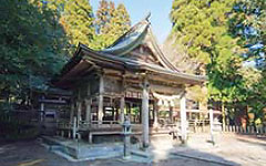
1Myougyouji
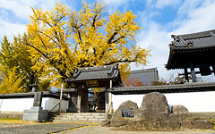
A temple with a history of 400 years in the Uchimaki shopping area. Soseki Natsume visited and was also a motif of the novel “210 days”, a stage setting. An old tree such as a large ginkgo or a bird drooping cherry colorizes the scenery of the ceremony.
-
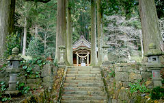
2Nishikozono hachimangu
Another name, “Women bee shrine” located in a place back from the street line. It is said that the couple ginkgo in the precincts exceeds 500 years of age, and they stand by side by side with each other.
-
3Kabarun park
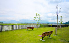
A community park where a local elementary school student gave a name. A bench is set up where Aso Gogaku can be seen well, and parents and children in the area often visit.
-
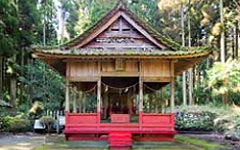
4Nishiyunoura hachimangu
Because it is performing a festival at the Tanabata of the lunar calendar, it is called “Tanabata san” and it is familiar. There is a legend of Orihime and Hikoboshi, and there is also a benefit of marriage.
-
5Yunoura hachimangu
The tradition of a male bee that struck Hiragamon and triggered the great turbulence remained, and it is called “male bee shrine”. At the example festival in September Kagura is dedicated once every two years.
-
6Fukunokami jizou
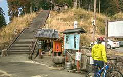
Jizo, who sat on a bales and held a lottery. It is said that there is a benefit of the lottery. The view from the Kato Ma Yunosu graveyard on the hill which climbed the side stairs is also recommended.
Route guide
| Hanaasobi | Elevation 470m |
MAP |
|---|---|---|
| 1250m | ||
| Imakin restaurant | Elevation 470m |
MAP |
| 2500m | ||
| Kabarun park | Elevation 480m |
MAP |
| 750m | ||
| Miyajidake shrine | Elevation 495m |
MAP |
| 1000m | ||
| Nishiyunoura mizube park |
Elevation 510m |
MAP |
| 1625m | ||
| Yunoura hachimangu shrine |
Elevation 495m |
MAP |
| 750m | ||
| Miyabarusugawara shrine |
Elevation 485m |
MAP |
| 1375m | ||
| Fuku-no-kami Jizou statue |
Elevation 475m |
MAP |
Route map
Ichinomiya route
18km
A treasure trove of a superb view was nestled in the caldera
It is the route which runs in the spacious Aso valley in the north part of the Aso caldera. Surrounded by Aso Goryakudai and outer ring mountain on every side, you can run while experiencing the caldera topography. It is packed with sightseeing places such as Aso Shrine and Kokonzakura Shrine, the spring water group of Miyaji, Okiwara, Teno, village scenery, and ancient burial mounds. As you can enjoy condensing the charm of Aso, it is recommended for beginners to advanced players.
Recommended spot
-
1Shimo shrine
A shrine in which a mysterious “fire fighting god” is held where a girl chosen in the district wishing for five grain rich foods will heat the gods with fire number for 59 days from August 19th. The fire fighting staircase, located opposite the main hall of the main hall, is also a notable sightseeing point.
-
2Yakuinbaru natural spring waters
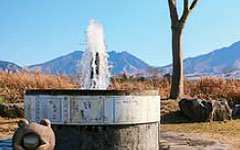
Among the springs of springs, spring water of Ikkyuhara, especially where water springs up rapidly. It is springing like a fountain in the rice fields and along the road. Would you like to heal from cycling fatigue with spring water?
-
3Aso central high cattle school barn
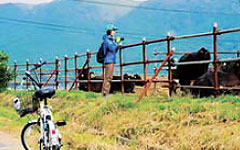
Aso Central High School is the only high school in Aso city. There are agricultural food departments, some students are studying animal husbandry. A nice day, you may meet an amber cow here.
-
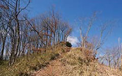
4Syouranzan
As it is similar to the view from Arashiyama in Kyoto, this mountain named “Koarashiyama” is a scenic atmosphere as its name suggests. As you climb the stairs, you can enjoy the landscape of the Nakdong Tumulus Group and Aso Gogaku.
-
5Kokuzou shrine
Enshrined Kuni no miyatsuko Daimyojin, one of the oldest Shrine Kumamoto. The approach of the solemn atmosphere is located on an extension line connecting the Aso shrine from the crater Nakadake, I feel the connection with the volcano faith.
-
6Road with a view of Aso’s five peaks
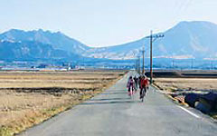
Caught in front of the Aso Gogaku, is the way that can run the spacious countryside is said to be “Aso thousand Hirata” in a straight line. Where the scenery is in the ordinary, there is a “luxury” that can run through the attractive scenery of Aso.
Route guide
| Ichinomiya information center |
Elevation 520m |
MAP |
|---|---|---|
| 3500m | ||
| Shimo shrine | Elevation 505m |
MAP |
| 1250m | ||
| Yakuinbaru natural spring waters |
Elevation 505m |
MAP |
| 1250m | ||
| Aso central High school cattle barns |
Elevation 495m |
MAP |
| 1750m | ||
| Syouranzan park | Elevation 500m |
MAP |
| 4250m | ||
| Kokuzou shrine | Elevation 550m |
MAP |
| 4750m | ||
| JA Aso Shikisai-chinomiya farmers market |
Elevation 510m |
MAP |
Route map
Namino route
To the place of “Aso”
Namino, as its name suggests, is a rugged terrain like a wave. Route to enjoy the up-down, it is recommended to those who are confident in cycling experts or physical strength a little hard. As the scenery changes quickly, crossing the pass or passing through the forest. Buckwheat fields and cabbage fields, such as the grazing of cattle, is a big attraction of the landscape also Namino of “livelihood” of every season.
Recommended spot
-
1Soba field
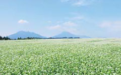
“Soba” of Namino’s specialty products. In September, white flowers are blooming all over. Especially the Soba field near the station Namino, you can enjoy the impressive landscape with Takadake and Nekodake as background.
-
2Chichinoki
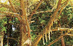
A big ginkgo tree near the Namino Branch. The airspace extends like a milk from a branch, and there is also a legend of breast feeding. It seems that neighboring women prayed for breast feeding with sweet sake.
-
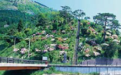
3“Nagomi no Hanamichi”
It is the way the community is making flowers to make visitors enjoy it. Before the challenge to Ogidake, enjoy the scenery of the flower road and enjoy the touch with the local people.
-
4Nakaekaguraden
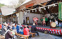
It is said that the Nakae Kagura Den which the “Nakae Iwato Kagura” of the country selection intangible folk cultural property is performed is the closest designated seat to the gods. On the first Sunday of April to November (excluding October) there is a regular performance of Kagura.
-
5Ogidake
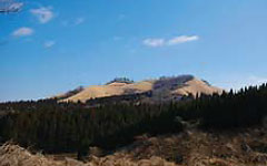
The altitude is 843 m, the highest mountain in the Namino area. At the top there is a view place,”Aso Gogaku” and “Sobo Katamuki-san”, such as Kuju Mountains, you can enjoy a 360-degree breathtaking panorama.
-
6Chausuduka
At the summit, the tea ceremony mausoleum dedicated to the god of the cattle horse “Kuratake-san”. You can climb a small mound, and you can see the Kuju mountain range. In the neighborhood, there are also “Yahata-sama” and “Otaishi-san”.
Route guide
| Mich-no-eki Namino Kaguraen roadside sattion |
Elevation 715m |
MAP |
|---|---|---|
| 2750m | ||
| Cattle grazing | Elevation 730m |
MAP |
| 2500m | ||
| JR Namino station | Elevation 760m |
MAP |
| 3000m | ||
| Kamameguri bridge (Izumitani River) |
Elevation 685m |
MAP |
| 5000m | ||
| Nakae kaguraden hall |
Elevation 690m |
MAP |
| 2000m | ||
| Ogidake peak | Elevation 830m |
MAP |
| 4750m | ||
| JR Rakimizu station | Elevation 655m |
MAP |
| 6250m | ||
| Namino Plateau Yasuragi koryukan Recreation center and Lodge |
Elevation 690m |
MAP |

